
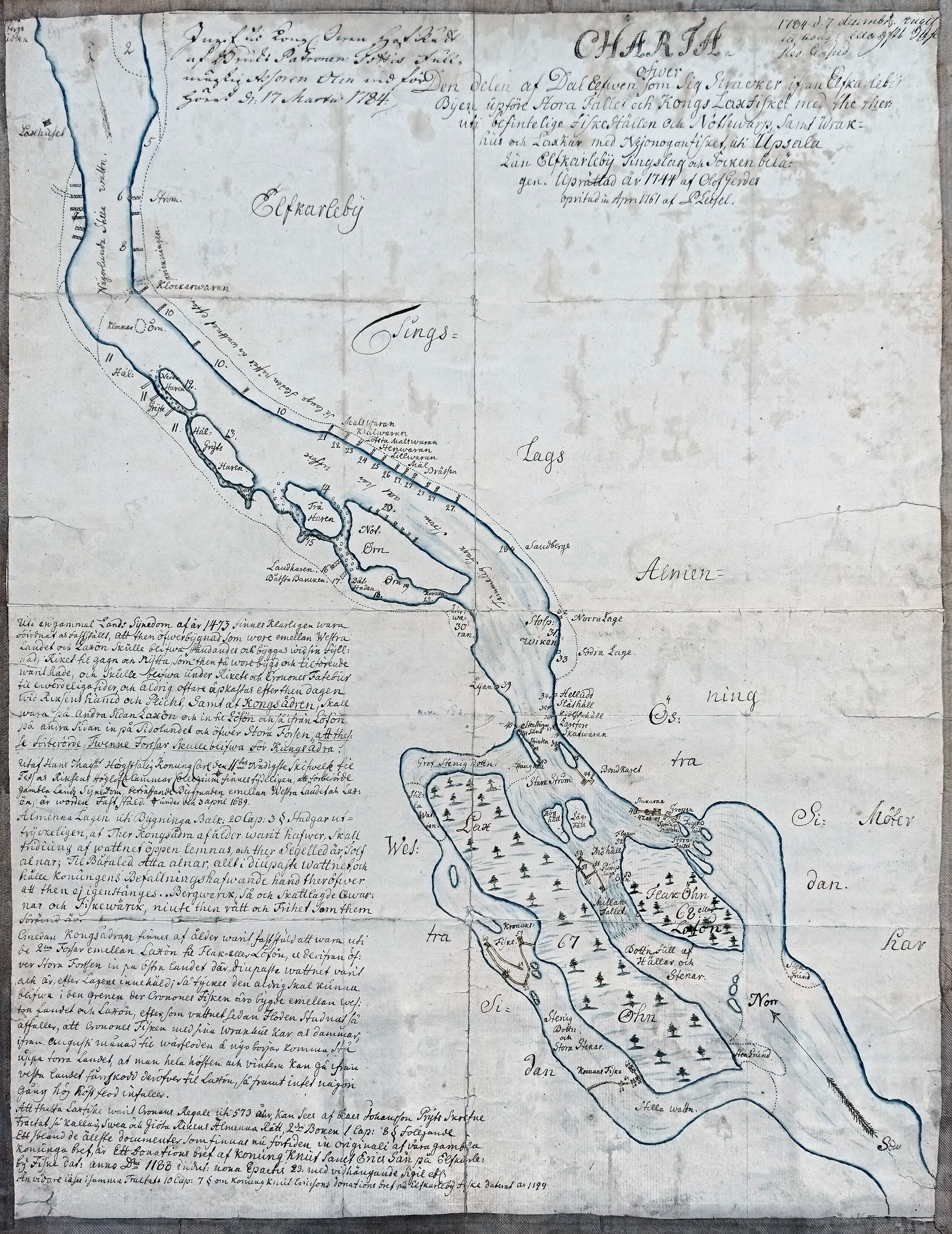
That part of the Dalriver which extends from the upper great waterfall at the village of Älvkarleby and the Royal salmon fishery-including the fishing sites and seine-hauling grounds located there...
This is the text I have transcribed from a map of the Dalälven River in Älvkarleby, which is part of the Tottie Collection. The map is held at the National Archives in Uppsala.
Olof Gerdes was a land surveyor from Uppland. P. Leijel appears to have drawn the map itself.
| Submitted to Kongl. Cammar Collegium by the ironworks owner regarding […] and […] Salmon[…] Gefle d. 9/17 March 1784. |
1784 d. 7th December, stated to Kongl. Cammar Collegium [Res.?] Exped. |
|
Click on the image for a large map |
CHARTAover |
|
|
An old land-survey judgment from 1473 clearly states and confirms that the structure between the Western Mainland and Laxön was to remain standing and be maintained in its full extent, for the benefit and use of the realm, as it had originally been built and held. It was to remain the property of the Realm and the Crown Treasury for all time and was never again to be challenged after that date, on pain of punishment and penalty by the Realm. It was also established that the King’s Channel was to run along the other side of Laxön to Lövön, and from Lövön along the other side toward the Eastern Mainland and across the Great Rapids, so that these two aforementioned rapids would remain the King’s Channel. A most gracious letter issued by His late Majesty King Charles XI to His Majesty’s and the Realm’s Honourable Chamber College clearly shows that the aforementioned old land-survey judgment concerning the structure between the Western Mainland and Laxön was confirmed on 3 April 1689. The General Law, in Chapter 20, Section 3 of the Building Code, expressly provides that wherever a King’s Channel has existed since ancient times, one-third of the waterway must be left open. Where there is a shipping channel, twelve ells must be left open; where there is a boat channel, eight ells—all measured in the deepest part of the water. The King’s governor shall ensure that the channel is not obstructed. Mines, as well as taxed mills and fishing works, shall enjoy the rights and privileges granted to them. Since the King’s Channel was established long ago as running through the two rapids between Laxön and Flakön, or Lövön, and from there across the Great Rapids toward the Eastern Mainland, where the deepest water was and still is, in accordance with the law, it would seem that it can never be moved into the branch of the river in which the Crown’s fishing works have been built between the Western Mainland and Laxön. Once the floodwaters have subsided, the water in that branch falls so low that the Crown’s customary fish traps and dams stand on dry land from August until the spring flood begins again. Throughout the autumn and winter, it is therefore possible to walk dry-shod from the Western Mainland across to Laxön, unless an unusually high autumn flood should occur. That the Western Salmon Fishery has been a royal prerogative of the Crown for 573 years can be seen from the treatise written by Clas Johansson Prytz, entitled The General Law of the Realms of Sweden and the Geats, Book II, Chapter 1, Section 8, as follows: Among the oldest documents still surviving in the original from our former kings is a deed of gift issued by King Canute, son of Saint Eric, concerning the Älvkarleby Fishery, dated in the Year of Our Lord 1188, in the ninth indiction, with an epact of 23, and bearing a pendant seal, etc. The same treatise, Chapter 10, Section 7, further mentions King Canute Ericsson’s deed of gift concerning the Älvkarleby Fishery, dated 1199.
|